
You’re a few miles from the truck; it’s midafternoon, and the weather still looks decent.
Mostly.
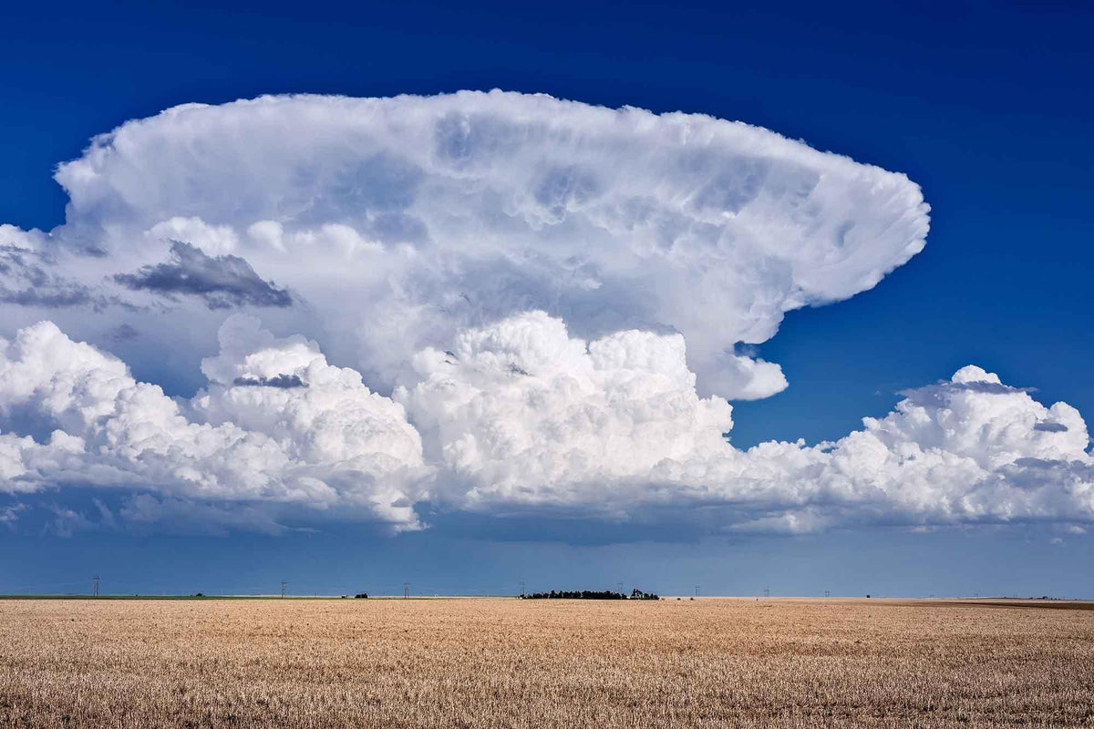
The little white clouds that were scattered around at lunch have changed. They’re taller now. One has gone from looking like a cotton ball to something closer to a mountain. Its base has darkened. The wind has picked up and shifted just enough that you notice it, and there’s a darker patch of sky developing off to the west.
Your weather app said there was only a modest chance of rain.
That forecast still matters. But so does the atmosphere directly over your head.
Knowing how to read that change is one of the more useful pieces of fieldcraft you can learn because weather rarely causes only a weather problem. Rain can become a shelter problem. Wind becomes a fire problem. Falling temperature becomes a clothing problem. Lightning changes where you can safely move. Fog can turn an easy route into a navigation exercise you didn’t volunteer for.
AFH 10-644 treats weather as part of the larger survival problem for a reason. You don’t need to become a meteorologist. You need enough understanding to recognize when conditions are trending in your favor and when the atmosphere is starting to stack the deck against you.

FIRST, UNDERSTAND WHAT MAKES A CLOUD
Strip weather theory down to the part that matters in the field and you can start with one question:
Is the air rising or sinking?
Air under a broad area of high pressure tends to sink. As it descends, it compresses and warms. That makes condensation less likely, which is one reason high pressure is usually associated with clearer and more settled conditions.
Low pressure tends to encourage rising air.
As air rises, the pressure surrounding it decreases. The air expands and cools. Cool it far enough and it eventually reaches the temperature where some of its water vapor condenses onto tiny particles already suspended in the atmosphere.
Now you have droplets or ice crystals.
Now you have a cloud.
That doesn’t mean every high brings sunshine or every low produces a storm. The atmosphere is more complicated than that. But as a working field model, rising air favors cloud development and unsettled weather; sinking air suppresses it. In the Northern Hemisphere, surface winds generally rotate counterclockwise around lows and clockwise around highs.
There’s even a field shortcut known as Buys Ballot’s Law. Stand with your back to the wind in the Northern Hemisphere and lower pressure will generally lie somewhere to your left.
Treat that as supporting evidence, not divine revelation. Hills, forests, valleys, water and local heating can all bend the surface wind around.
The next thing to understand is stability.
Stable air doesn’t like moving upward very far. When cloud forms in stable air, it tends to spread out into sheets and layers.
Unstable air is more willing to rise. That produces clouds that grow vertically.
That distinction is extremely useful because it gives you something you can recognize without knowing a cloud’s name:
Flat and layered usually means stable. Tall and growing means unstable.
And unstable air is where the interesting weather lives.
FRONTS: WHY SOME WEATHER CREEPS IN AND SOME ARRIVES WITH A SHOVEL
Different air masses don’t always mix politely.
A cold front forms when a colder, denser air mass advances and wedges underneath warmer air. The warm air gets shoved upward. If there’s enough moisture and instability present, that relatively abrupt lift can produce showers, thunderstorms, gusty winds and sharp temperature changes.
Cold fronts tend to move faster than warm fronts, which is why deteriorating weather can arrive quickly.
A warm front is different. Warmer air advances toward cooler, denser air and gradually rides up over it. Because the slope is much gentler, the lifting occurs over a much wider area.
That gives you one of the best visual forecasting sequences available to somebody standing on the ground: the clouds often start high and thin, then become progressively thicker and lower as the front approaches.
A cold front has a tendency to show up at the door.
A warm front sends several letters first.
Now you can start reading those letters.
HIGH CLOUDS: WHAT SHOWS UP BEFORE THE WEATHER GETS HERE
High clouds generally have bases somewhere above roughly 16,000 to 20,000 feet, depending on latitude, season and which classification system you’re using. At those temperatures, ice crystals make up much of what you’re seeing.
Cirrus: the feathers
Cirrus clouds are thin, fibrous streaks high in the sky. They can look like feathers, hooks, horse tails or paint dragged across blue sky.
A few isolated cirrus clouds aren’t much of a forecast. They can occur during perfectly good weather.
What matters is the trend.
If there are noticeably more cirrus clouds this afternoon than this morning, they’re spreading from one direction, and the coverage continues increasing, you may be seeing moisture arriving high in the atmosphere ahead of a larger system.
Don’t think, “Cirrus means rain.”
Think, “Cirrus that is increasing means I should keep watching.”

Cirrostratus: somebody pulled a veil across the sky
Cirrostratus is easier to overlook.
The sky often still appears bright. You can see the sun or moon through the cloud. But instead of individual wisps, much of the sky becomes covered by a thin whitish sheet.
Then you notice the ring.
A large halo around the sun or moon is one of the better clues that you’re looking through ice crystals in cirrostratus. If you had increasing cirrus several hours earlier and now a broad halo has appeared, the evidence for an approaching system is getting better.
This is where the old saying about a ring around the moon and rain coming soon gets its footing. The halo itself isn’t predicting the rain. It’s identifying the kind of high-level moisture that often arrives ahead of a frontal system. Rain or snow may follow later that day or during the next.

Cirrocumulus: fish scales overhead
Cirrocumulus is made of very small white cloud elements arranged in patches, ripples or rows.
From the ground it can look like somebody covered part of the sky in fish scales. That’s the classic “mackerel sky.”
These clouds are high enough that each individual element appears tiny. A useful observation trick is to extend your hand at arm’s length: true cirrocumulus elements are generally smaller than the width of one finger, while the pieces in lower altocumulus appear larger.
By itself, cirrocumulus isn’t an immediate bad-weather warning. It tells you the upper atmosphere contains moisture and structure that weren’t necessarily there before.
In other words, conditions are worth watching rather than assuming the rest of the day is guaranteed.

MIDDLE CLOUDS: THE SYSTEM IS GETTING CLOSER
Middle-level clouds generally occupy the neighborhood between about 6,500 and 20,000-plus feet. The exact dividing lines vary among references, which matters far less in the field than recognizing that the cloud deck is becoming lower and thicker.
Altostratus: the sun behind frosted glass
Altostratus usually covers a large portion of the sky.
It’s gray or blue-gray and often thick enough that the sun becomes a dim disk rather than a bright object casting sharp shadows. If you can see the sun, it looks like you’re viewing it through ground glass.
This is where that earlier high-cloud progression starts getting serious.
You saw wispy high cloud.
Then the sky developed a thin veil.
Now the cloud deck has thickened enough to dim the sun.
That’s not random cloud traffic. In the right setting, you’re watching warm, moist air being lifted over cooler air as a frontal system approaches. Continued thickening can lead to widespread precipitation.

Altocumulus: look at the shape, then look again later
Altocumulus appears as patches, rolls or rounded masses that are noticeably larger than the tiny grains of cirrocumulus.
Sometimes it’s harmless.
Sometimes it deserves attention.
One especially useful clue is altocumulus showing noticeable vertical development during a warm and humid morning. Turreted or castle-like altocumulus can reveal instability higher in the atmosphere before thunderstorms develop later in the day.
You don’t have to know the Latin name for every subtype.
Just notice when supposedly middle-level clouds are starting to grow upward.
Upward growth is the part you care about.

LOW CLOUDS: YOU’RE GETTING INTO THE WEATHER NOW
Stratus: fog with some clearance underneath it
Stratus is low, flat and usually gray.
If you’ve ever stood underneath a featureless overcast that seemed to sit barely above the trees, you’ve probably seen it.
Fog is essentially a cloud sitting at the surface. Lift that same general type of cloud off the ground and you have a useful mental picture of stratus.
Stratus may bring mist or drizzle, but it isn’t normally the source of violent weather. Its bigger field effect can be reduced visibility, wet vegetation and everything becoming progressively damp without enough rain to make the experience interesting.

Stratocumulus: low, lumpy and generally restrained
Stratocumulus combines the broad horizontal character of stratus with more obvious rounded or lumpy elements.
You may see rows, rolls, patches or a honeycomb-like deck with breaks between them.
There’s moisture around, but strong vertical development is usually being limited. If the deck begins breaking apart, conditions may be improving. If the entire sky is steadily filling, lowering and darkening, keep watching what replaces it.

Nimbostratus: settle in, it’s going to be wet
Nimbostratus is what happens when the layered cloud system becomes thick enough to produce widespread, sustained precipitation.
The sky turns dark gray. The sun disappears. The cloud base may become difficult to define because precipitation is falling underneath it.
This isn’t generally the dramatic thunderstorm cloud.
It’s the cloud that rains on you for hours.
If you watched cirrus become cirrostratus, then altostratus, and finally arrived underneath nimbostratus, you just watched a large-scale frontal progression unfold from start to finish.
That’s field forecasting.
Not magic. Just paying attention for long enough.

THE CLOUDS THAT SHOULD MAKE YOU WATCH THE CLOCK
Now we get to convection.
Cumulus: harmless until it starts winning
A normal fair-weather cumulus cloud has a relatively flat base with a bright, rounded top.
It forms because warmer air near the ground rises. Once that air cools enough, condensation begins and the visible cloud starts.
If the atmosphere is fairly stable above it, the cloud doesn’t get far.
It stays small.
Maybe it grows a little during the heat of the afternoon, then weakens as the ground cools later in the day.
No great mystery.
But you’re not watching for the cloud merely to exist. You’re watching for change in its vertical growth.

Towering cumulus: this is your warning stage
Take that same cumulus and give the rising air more instability.
Now it keeps going.
The cloud develops large, sharply defined cauliflower towers. The top builds visibly higher. The bottom gets darker because the cloud is becoming deeper.
That’s towering cumulus, also called cumulus congestus.
This is one of the most useful clouds to recognize because you’re catching the process before a mature thunderstorm has necessarily formed.
If you look at the same cloud fifteen or twenty minutes later and it’s dramatically larger, that matters.
Get the shelter ready.
Put rain gear where you can reach it.
Secure anything that doesn’t need to become somebody else’s gear.
If you were planning on walking a ridge or crossing exposed ground, reconsider the schedule.

Cumulonimbus: the decision has already been made for you
Once the tower becomes enormous, the base darkens heavily and the top starts spreading outward into an anvil, you’re looking at a mature thunderstorm cloud.
That spreading top forms because the updraft has reached a much more stable layer near the upper boundary of the troposphere and can no longer keep rising freely, so the cloud spreads horizontally.
Cumulonimbus can bring lightning, intense rain, hail, violent gusts and sometimes tornadoes.
At that stage you’re no longer forecasting instability.
You’re looking at it.
THE REAL SKILL ISN’T NAMING CLOUDS
Cloud identification is useful.
Trend identification is better.
Say you’re camping and thin cirrus arrives during the afternoon.
By evening, there’s noticeably more high cloud.
After dark, the moon develops a broad halo.
The next morning the sky is gray enough that the sun looks blurred behind it.
A few hours after that, the sun disappears completely and steady rain begins.
You didn’t need a barometer to see what happened.
You watched a cloud deck progressively thicken and lower as a system approached.
The opposite trend matters too.
If a thick gray morning deck begins breaking apart, cloud bases lift, patches of blue expand and the wind becomes less aggressive, that points toward improvement.
Think in verbs rather than nouns.
Is the sky building, lowering, thickening, spreading and darkening?
Or is it lifting, thinning, breaking and flattening?
Those trends can be more useful than correctly identifying a single cloud while ignoring everything else around it.
ADD WIND AND TEMPERATURE TO THE PICTURE
Now suppose that dark western sky is getting closer.
The wind suddenly shifts.
Then a noticeably cooler gust hits you.
That combination deserves your attention because a cold front or thunderstorm outflow may be approaching rapidly.
You’ve now stacked several observations together:
- The cloud is darker.
- The direction is consistent.
- The wind changed.
- The temperature fell.
The timeline just got shorter.
Wind direction itself can also help. A wind that gradually turns counterclockwise with time is called backing. Clockwise turning is called veering.
These shifts can provide useful information around frontal passages, but they’re best used as supporting evidence rather than a standalone forecast because terrain can distort surface winds badly.
Again: stack clues.
Don’t bet the day on one.
A TEN-MINUTE FIELD WEATHER CHECK
Before you leave shelter, commit to another section of trail, move farther from the vehicle or decide to squeeze another hour out of daylight, stop moving for a few minutes.
Actually look.
- Start at the horizon. What is approaching you? Scan the entire sky and compare one side with the other.
- Look at cloud bases and tops. Are clouds getting taller, merging, lowering or darkening? Can you still see the sun?
- Use a fixed reference. Pick a tree, ridgeline, tower or building and watch how the cloud deck moves against it.
- Notice the air. Did the wind shift or strengthen? Did the temperature drop? Does the air feel suddenly cooler or more humid?
- Compare the trend with the forecast. If the forecast called for afternoon storms and cumulus clouds are already towering by noon, take that seriously.
If the forecast called for clear weather but the atmosphere over your actual location is rapidly deteriorating, don’t argue with the sky because a percentage on your phone looked more convenient.
THREE OLD WEATHER SAYINGS THAT ACTUALLY HAVE SOMETHING BEHIND THEM
A halo around the moon has already been covered. You’re often seeing ice crystals in cirrostratus, and that cloud can precede a larger system.
The old “mackerel sky” saying has similar roots. Those rippled upper clouds don’t guarantee rain, but they can show that conditions aloft are changing.
Then there’s the famous red sky.
The rule works best in the middle latitudes because many weather systems there tend to progress broadly from west toward east.
If the western sky is clear enough at sunset for low-angle sunlight to illuminate particles through relatively dry air, improving weather may be approaching from that direction.
A strong red sunrise can mean the clearer air is already east of you while the next system lies to the west.
Useful clue?
Yes.
Binding contract with the atmosphere?
Absolutely not.
KNOW WHEN YOUR EYES AREN’T ENOUGH
Visual forecasting has limits.
A thunderstorm can develop behind terrain where you can’t see it. Weather systems can be moving toward you from beyond the horizon. Radar can see precipitation your eyes cannot. Satellites can watch cloud development across entire regions.
So if you have access to current National Weather Service forecasts, warnings, radar or NOAA Weather Radio, use them.
Field observation complements those tools.
It doesn’t replace them.
Your eyes are especially useful for the next several hours because they tell you what the atmosphere is doing where you actually are.
And that’s often the period that matters most when deciding whether to make camp, change route, seek better shelter or postpone movement.
The same philosophy applies to preparedness equipment. Black Label Precision’s FIELD//MOD modules are there to help solve problems when you’re away from the easy answers, but recognizing deteriorating conditions early gives you something even better than equipment: time to use that equipment on your terms.
Don’t wait for rain hitting your face to decide it looks like rain.
Look up sooner.
FURTHER READING AND FIELD REFERENCES
For the source material behind this article, start with the official U.S. Air Force SERE handbook. Chapter 6 provides the survival-weather framework this FIELDCRAFT article builds from. AFH 10-644 — Survival, Evasion, Resistance and Escape Operations.
NOAA’s JetStream material goes deeper into cloud identification and explains the ten basic cloud families. NOAA JetStream — Ten Basic Clouds.
For a printable field-reference visual, NOAA’s Cloudwise chart shows high, middle and low cloud types along with different stages of development. NOAA Cloudwise Cloud Chart.
For a simple explanation of pressure systems and warm and cold fronts, use the National Weather Service primer. National Weather Service — Pressure Systems and Fronts.
NASA/JPL provides another beginner-friendly cloud-identification lesson with observation exercises. NASA/JPL — The Types of Clouds and What They Mean.
Readers who want the underlying meteorology in more depth can use the FAA’s Aviation Weather Handbook, which covers weather theory, fronts, stability, convection and weather hazards. FAA-H-8083-28B — Aviation Weather Handbook.
Share:
THE SECOND EMERGENCY: What SERE Medicine and Weather Teach Civilians
READ THE LAND: HOW TERRAIN, CLIMATE AND LIFE WORK TOGETHER